Hamilton to be hit with major wind storm today
- Robert Cekan
- 24 Feb 2019
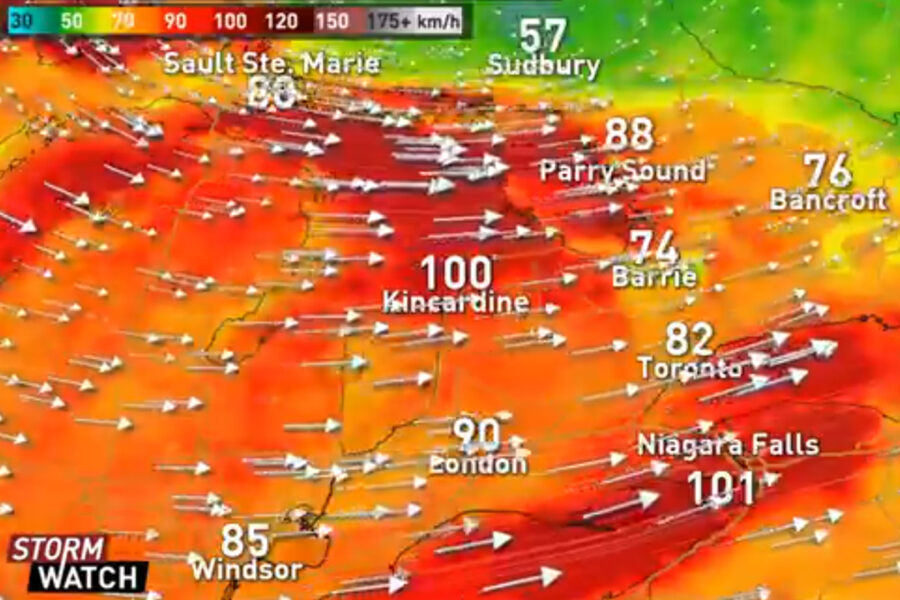
Environment Canada has issued a weather statement warning of damaging westerly winds gusting 100 to 110 km/h for Hamilton.

Areas near the shores of Lake Huron and Lake Erie are expected to experience the most severe wind gusts, potentially reaching 120 km/h.
The storm will persist throughout Sunday, gradually weakening on Monday.
This map shows wind gust at 4 pm Sunday. The yellow is 60-70 knots (about 110-130 km/h). Given that the ice on the lake is not fast (attached to the land), it will move easily. This may be a high impact event for Niagara/Buffalo. @jwhittalTWN @weathernetwork #ONStorm pic.twitter.com/ZdR2CPMQJ4
— Mark Robinson (@StormhunterTWN) February 23, 2019
Amplifying the dangerous conditions are flurries with up to 5 cm of snow and ice that will commence this morning.
A fresh snowfall with heavy winds can create near whiteout conditions, warns Environment Canada. Travel is not advised as roads will become hazardous due to the decreased visibility.
Storms of this scale have the power to knock power lines, tear shingles off roofs, and even tip bolted signs over as evidenced in last year’s wind storm.
It’s recommended to stay off the roads today, and to secure outdoor items such as recycling bins and garden tools.
Let us know your tips to brave today’s storm in the comments below!
Header photo courtesy of The Weather Network
Comments 0
There are no comments
Add comment